Forget about all of those ubiquitous police surveillance cameras in your city: the new sheriff in town is that shifty Google Street View camera wheeling through your neighborhood. Even though Google Maps, has been garnering criticisms for its alleged privacy invasions, but it is actually a pretty good crime-solving tool, and it is being embraced by police all over the world.
Of course besides acting a handy tool for the police, Google Maps, Google Street View and Google Earth can also be used for a plethora of things too.
Below are 5 examples of how the three Google products have helped police solve crimes.
Marijuana Field
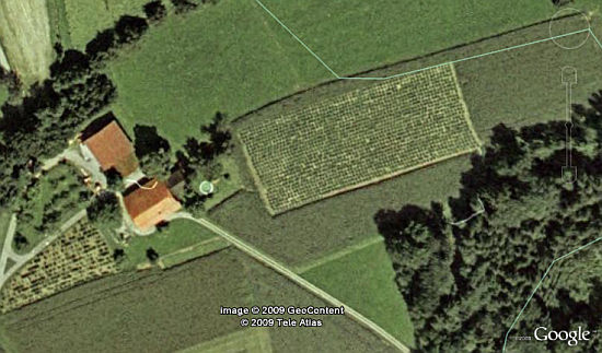
Swiss cops managed to discover a two-acre-large planation hidden in a field of corn while using Google Earth, and this crucial tip led them to solving a bigger part of their investigation of an alleged drug ring in the northeastern state of Thurgau. The officers were apparently trying to use the search engine juggernaut’s satellite software to find the full addresses of the location, but stumbled across the 7,500 m2 illicit horticultural site instead. 16 people were arrested and a seizure of 1.2 tons of marijuana with a street value of US$2.5 million had been yielded.
Illegally Dumped Boat
 Harnessing Google’s popular mapping software, technologically-savvy Santa Rosa County Sheriff’s Deputy Gregory Barnes managed to track down the owner of an illegally dumped boat. Dwight Everett Foster probably thought that no one would know about his wrongdoing of abandoning his 18-foot boat in an undeveloped subdivision about 15 miles north of Pensacola.
Meanwhile, Barnes took his investigation online after realizing that the vehicle identification number and registration had been removed. After scouring the satellite-generated imagery on the software, he noticed a blurry shape resembling the boat on the property of Foster.
“He saw something that looked an awful lot like the boat in question,” said Sgt. Scott Haines, spokesman for the Santa Rosa County Sheriff’s Office. “Then he drove by the property and discovered an empty boat trailer, as well as other evidence.”
“I can tell you that law enforcement now uses Google Earth quite a bit,” added Haines.
Kidnapping Drama
 A 52-year old grandmother had allegedly kidnapped her 9-year old granddaughter, and the police in Massachusetts were called in to track down the girl’s whereabouts. They had managed to obtain coordinates of her cell phone from the phone’s carrier and traced it to an intersection in Virginia.
Since they were in Massachusetts and couldn’t just drive to the other side of town to take a look, they turned to Google’s mayhem monitor instead. After punching in the coordinates on Google Street View, they soon found out that girl and her grandmother were staying in a motel somewhere in Virginia. And to validate the location further, the police authorities used Google Satellite View. With further ado, they called the Virginia State Police, who then headed to the motel and found the girl with her grandmother.
Tree Assassin
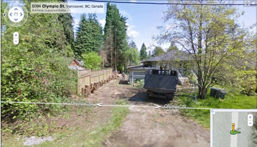
Margaret Burnyeat, of Vancouver, Canada, allegedly hired a company to chop down some 23 cedar, cypress and evergreen trees from her property, and was charged with illegal removal of trees. Unfortunately for Margaret, the arboreal assassins in action were caught by one of Google’s fleet of Street View camera cars, which coincidentally passed by Burnyeat’s property when the axing occurred. As seen from the screenshot above, a truck on the site, as well as workmen and a row of fresh tree stumps had been photographed.
“Our city’s legal department is aware of that. How they will use that as evidence, I’m not clear. But it is an interesting new dimension, perhaps, of legal evidence,” a city spokeswoman told a local news service.
Robbery
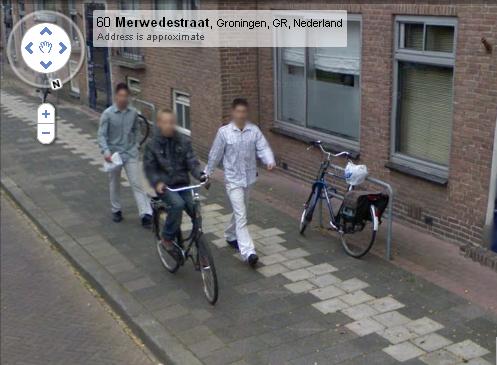
While riding his bike down the streets of Groningen, a 14-year-old was yanked off his bike by two Dutch twin brothers who then purloined his cell phone and €165 cash ($230). The boy reported the crime to police in September 2008, but the investigation did not produce any leads. However, six months later, he happened to stumble across the above image of himself and the two robbers while surfing Google Maps. The incident took place in Groningen, 110 miles northeast of Amsterdam.
“The photo could provide an important contribution to solving a crime,” said Paul Heidanus, a spokesman for the Groningen police.
With this crucial evidence in hand, the Dutch police immediately asked Google for the original image, with faces unblurred (Google blurs faces for privacy reasons). A detective recognized one of the attackers, and police immediately arrested two suspects.